Introduction
01.01 Time and Place in History: Objectives
How Ancient Is the Earth?
The story of humans on the earth goes back many thousands of years. At one time, our ancestors moved from place to place following animal herds. They knew little about the powerful forces that created weather, made mountains, or moved the tides of oceans. As time passed, people learned to write. Then they gave names to the periods of time – both great and small – that made up their present and past.
Some began to understand how to map their surroundings. They also figured out ways to record the progress of people and ideas across time. Today, we call such efforts the study of history and geography – time and place. History and geography can help us see what our world looks like. They can also help us see where we have come from. And in many cases, they help us think about where we are going. You will answer multiple-choice questions on how to discover time and place in history for this lesson’s assessment.How Do We Mark Time?
History is a record of past important events and their causes. People existed before writing began, however, and that time is known as pre-history, or before history. So why is history important to us today? Because things that happened in the past have shaped the world as we now know it. And, as the popular saying goes, "If we do not learn from history, we are bound to repeat it."
Without time, history would not exist. Time divides the past up into different periods. In history, we often talk about groups of things that happened in terms of periods. Just think about important things that have happened during your own history:
Birth
Started to walk
Started to talk
Learned the alphabet
Started school
A useful way to think about these past events is to use a timeline to show them. Charting out events visually often makes them easier to understand. It also helps to put events in context with other happenings in the world.
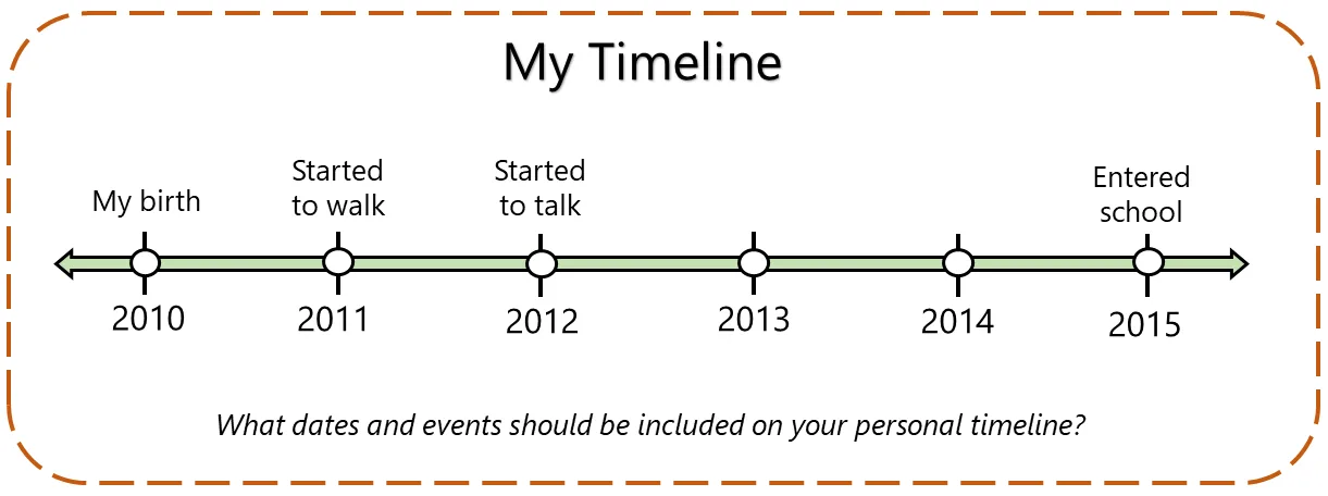
Timelines are read from left to right, or top to bottom. Years or other important dates are usually located below the line. Information about the dates appear above the line. Timelines are divided into intervals. Events are shown in chronological order. A timeline of your life would look something like the image shown here.
The world has a timeline as well. So much time has passed throughout history, it is necessary to divide it up to help us understand it. Terms you'll see frequently when discussing years are BCE (or BC) and CE (or AD). BCE means "Before Common Era," and CE means "Common Era." This way of showing time came about around the 17th Century (which would be CE). Year 1 CE would come directly after Year 1 BCE on a timeline. The terms "BC" and "AD," which mean "Before Christ" and "Anno Domini" (a Latin phrase that shows time after the traditional birth of Christ), can be used in place of BCE and CE. For example, 1 BCE is also 1 BC, and 1 CE is also 1 AD.
Years before 1 are considered BCE, and years after 1 are considered CE. The years in your personal timeline are in CE. There is one key difference between counting years in BCE and CE. When counting time in BCE, the years decrease as you approach CE on the timeline.

Chronology uses various units of time such as millennium, century, and decade. Eras refer to periods of time but not specific numbers of years. Epochs are events or times that begin with a new period of development.
For example:
The era of the Roman Empire in western Europe ended in 476 AD.
The epoch of pre-history ended when humans began using writing to record their experiences.
Match each term with the time period it represents.
Drag each term onto its matching definition.
Terms
Definitions
0 of 5 matched
How Do We Determine Location?
Time is an important measure for studying history and so is place. How can we understand things that have happened in the past if we do not know details about where they have happened?
One of the most powerful tools we can use to understand place are maps. There are different kinds of maps that show places in different ways. This helps us to see information from viewpoints that can help answer questions or solve problems.
Maps help us understand where a place is located in space. There are two types of locations: absolute and relative. Absolute location is the exact spot on the planet where a place is located. For example, if someone asks you where you live, you would probably give your street address. A street address is an absolute location. An absolute location can also be latitude and longitude coordinates. Latitude and longitude lines can tell you a place's exact location in the world.
Another way to describe a place's location is to tell where it is in relation to another place. This is called relative location. You might describe the place you live as "near the library" or "one mile west of the courthouse."

How Do We Divide the Earth?
Specific locations of cities and other features on Earth can be found by using longitude and latitude lines. Lines of longitude and latitude are imaginary. When these lines cross, they make coordinates. Coordinates are measured in degrees. Longitude lines run north and south. They are sometimes called meridians. Longitude distances are measured east or west of the Prime Meridian. Latitude lines run east to west around the Earth. They are also called parallels. They display distance in degrees north or south of the equator. The Tropic of Cancer is the line of latitude at 23.5° N of the equator. The Tropic of Capricorn is the line of latitude at 23.5° S of the equator. These lines help to separate geographical zones.

© 2012 FLVS

© 2012 FLVS
Hemispheres are also imaginary. They represent half the globe. The globe can be divided into northern and southern hemispheres and eastern and western hemispheres.

© 2012 FLVS
What Types of Maps Can We Use?
The surface of the Earth is not flat, but curved. Mapmakers have had to come up with creative ways to display maps on paper. These efforts are called projections. Flat maps cannot show sizes, shapes, and directions in the right way. All projections distort some parts of the Earth's surface.
Other than different map projections, there are also different kinds of maps that can show different kinds of information.
Select the tabs below to learn about these kinds of maps. Once you have done that, you can learn more about the map projections and then quiz your knowledge!
Africa, Political Map
Political maps like this one show things that humans have created. Cities, states, provinces, territories, and countries are often shown on political maps.

What Is Geography?
So far, you have learned about maps and how they are used. You have learned that they can show different things. You've learned about time, as well. Time and maps are both important parts of history and the land we have come from. When we start to think about land, we start to think about how geography affects our world and our history.
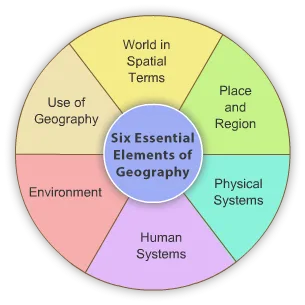
Geography is the study of how living and nonliving things have an effect on each other. There are Six Essential Elements of Geography. Each part helps you to understand the world and its people. Review the chart below to learn more about the Six Essential Elements of Geography:
Tap a numbered point to learn more.
Finish the activities on this page to mark it complete.